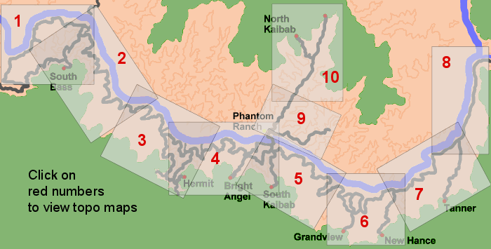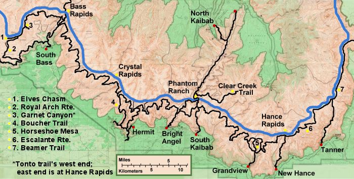
From the river you hike west on the Escalante Route, which is a de-facto extension of the Tonto Trail. The Tonto doesn’t officially start until Red Canyon, a roughly 10-mile hike from Tanner. The Escalante is indeed a route instead of a trail in some places, where there is more than one way to get where you want to go. Around Seventy-five Mile Canyon and Papago Creek, fluctuations in the river level will force you decide between a lower and an upper route. (The upper route is usually the choice.) Some people find that a 20-foot rope comes in handy at two points: For lowering packs where the trail dips into the narrow and steep-walled drainage of Seventy-five Mile Canyon, and for lifting packs during a climb through rockface just west of Papago Creek.
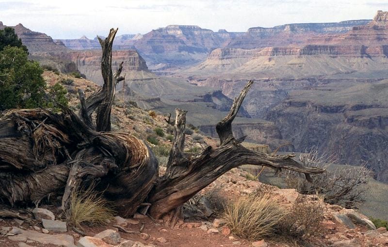
View from north end of Horseshoe Mesa.
(March 1990)
Farther west, Horseshoe Mesa and the Grandview Trail — the way out — can be reached via either Hance or Cottonwood canyon. Both canyons have plenty of water in early spring. The climb to the mesa is probably more interesting via Hance: an abandoned copper mine and a year-round spring are trailside attractions.
Ice and packed snow can make the upper portion of Grandview very treacherous in winter and early spring. And even when the trail is dry, it can break your heart. Many a hiker has been fooled into thinking he was almost at the top when there actually was nearly an hour yet to go. The trailhead, at 7,400 feet, is the South Rim’s highest.

Rainbow over upper Red Canyon.
(March 1995)
New Hance (Red Canyon) to Kaibab
The upper part of the New Hance Trail is frustrating: constant twists, turns, switchbacks, protruding pine branches, boulder-hopping, etc., and hardly anyplace to really stride out until the base of the Redwall. We covered this route in March 1995 and started out in a cold, drenching rain and wind gusts that could knock a person over. About four hours later, things had really changed: We were in T-shirts as the sun beat down on the canyon’s desert interior. But that wouldn’t last long, either: At nightfall at camp down by the river, the rain started again — and didn’t stop until the next morning. We found out later that the storm had caused landslides and floods in other parts of the canyon, forcing the closure of the Bright Angel and Kaibab trails and knocking out the water line that supplies the South Rim. We were lucky all we got was a little wet.
The Tonto Trail west from Red Canyon goes through Hance and Cottonwood canyons, mentioned in the previous section. Then comes Grapevine Canyon, with its springtime creek forming dozens of pools in the slickrock streambed. There actually were two creeks when we visited in 1995, in adjoining arms of the canyon. Luckily, this was where we had scheduled a rest day, and we were glad to spend the extra time there.
About three and a half hours west of Grapevine is Lonetree Canyon, another pleasant spot with seasonal water. Unfortunately, four of us — Lloyd, Marlene, Loretta and Joe — overshot Lonetree and hiked all the way to Cremation Canyon, our next day’s destination. So Stan and Barb had Lonetree all to themselves. Meanwhile, the four of us stayed at Cremation, which is nearly as desolate as the name suggests.
From Cremation, it’s about three hours to the rim via the Kaibab Trail. Lloyd did it in two and a half hours — not bad for a guy about to turn 50.

Bob and Dennis on the Kaibab.
(August 1972)
Kaibab and Bright Angel
The Kaibab and Bright Angel are the two main tourist trails — well-maintained, wide, practically impossible to get lost on. These crowded trails are not most backpackers’ idea of getting away from it all. But if you can’t get an overnight permit and you’re intent on making it to the bottom, this route is probably your only option: With enough energy, water and daylight, you can go down the Kaibab all the way to the river and up the Bright Angel in a day. That’s what Joe did on his first canyon hike, in 1972, even though the Park Service strongly discourages it.
The accompanying photo is from that first hike. Bob, Dennis and Joe, in canvas sneakers, took turns lugging that huge water jug. At lunchtime at the bottom, things took a troubling turn when Bob lost a sock in the river. He hiked all the way out with one foot sockless. The last we heard, he had never returned to the Grand Canyon.
In 1977, Stan did his first canyon hike: down and up the Kaibab with Jim. They didn’t carry enough water on the way out, so they got a bit delirious. In their extreme thirst, they resorted to munching on trailside snow — including the stuff turned yellow and green by the park’s pack mules.